ANAGA MOUNTAINS

EXPLORING THE

Hikes 1 to 10

DISCOVER OUR HIKES IN THE ANAGA MOUNTAINS

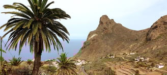
The Anaga mountains make up the oldest part of Tenerife. Located in the northeastern tip of the island, this biodiverse region is one of the best places to hike in the Canary Islands.

From misty forest walks to exhilarating coastal trails, the Anaga massif offers scenic variety, solitude, and arguably the best views of Tenerife’s coastline. Anaga feels like a prehistoric paradise with its jungle-like laurel forest, whimsical dragon trees, and green-carpeted peaks and ravines.

Hiking in the Anaga Mountains region

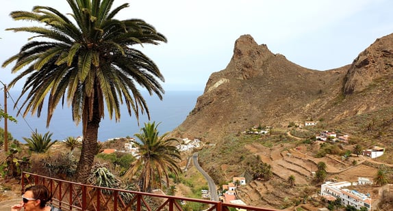
Laurel forests, steep cliffs and charming villages in the Anaga Mountains.

The north-east of Tenerife is a little-known area to many. The Anaga mountain range is home to fairytale laurel forests combined with steep cliffs, and it is remarkably greener than the rest of Tenerife.

There is also regular fog and it is always a few degrees cooler here than elsewhere on the island. For many hikers, Anaga is one of the most beautiful and spectacular areas on Tenerife to hike with unspoilt caminos (footpaths) for all levels.

8km

BARRIO NUEVO

Total distance of this hike?
From the capital to the feet of Anaga
How many altimetres?

533m

Loop or not?
Loop or not?

YES

Not recommended for people with vertigo!

YES

7km

Total distance of this hike?
How many altimetres?

400m

Loop or not?
Loop or not?

NO

Not recommended for people with vertigo!

NO

The Wild North Coast to Benijo

TAGANANA ► BENIJO

10km

EL PORTEZUELO

Total distance of this hike?
The green valley of Tegueste
How many altimetres?

425m

Loop or not?
Loop or not?

YES

Not recommended for people with vertigo!

YES

15.2km

IGUESTE ► PLAYA ANTEQUERA

Total distance of this hike?
Extreme hike to the hidden beach
How many altimetres?

1115m

Loop or not?
Loop or not?

YES

Not recommended for people with vertigo!

YES

6.5km

EL PIJARAL

Total distance of this hike?
Through the enchanted forrest
How many altimetres?

345m

Loop or not?
Loop or not?

YES

Not recommended for people with vertigo!

NO

5km

AROUND TAGANANA

Total distance of this hike?
The white village in Anaga
How many altimetres?

350m

Loop or not?
Loop or not?

YES

Not recommended for people with vertigo!

NO

7km

CANALES DE BEJIA

Total distance of this hike?
Through the Barranco Seco
How many altimetres?

550m

Loop or not?
Loop or not?

YES

Not recommended for people with vertigo!

YES

4.5km

ROQUE DE TABORNO

Total distance of this hike?
The Matterhorn of Tenerife
How many altimetres?

270m

Loop or not?
Loop or not?

YES

Not recommended for people with vertigo!

YES

13km

CRUZ DEL CARMEN ►PUNTA DEL HIDALGO
Total distance of this hike?
5* Hike on the PR-TF10
How many altimetres?

1450m downhill

Loop or not?
Loop or not?

NO

Not recommended for people with vertigo!

YES

13km

PRESA TAHODIO - CAMINO LECHERAS -JARDINA

Total distance of this hike?
Around the valley of Tahodio
How many altimetres?

790

Loop or not?
Loop or not?

YES

Not recommended for people with vertigo!

YES

LIST ALL OUR HIKES IN THE ANAGA MOUNTAINS

If you want an instant overview of all our hikes in the Anaga Mountains region , check our Wikiloc page for more information and GPX-files.